Moutain lake

An early start, as it was sunny and the rain was forecast from noon onwards.

We walked up a valley to Slovakia’s largest mountain lake, Vel’ké Hincovo pleso, at an altitude of 1948 metres. As the clouds had already moved in, we did not see the point of climbing up to Kôprovský štit, which offers great views of the lake and mountains around when the weather is good.

John could not resist going for a dip in the clear and cold water.

Un départ bien matinal car il faisait beau et la pluie était prévue dès midi.

Nous avons remonté la vallée pour atteindre Vel’ké Hincovo pleso, le plus grand lac de montagne de Slovaquie, à 1948 m. Les nuages étant déjà bien installés, nous avons renoncé à gravir le Kôprovský štit qui, par beau temps, offre de belles vues sur le lac et les montagnes environnantes.

John n’a pas résisté à l’attrait d’une baignade dans les eaux claires et froides du lac.

Before the storm

For our first hike in the Tatra mountains we thought we would do a loop through two valleys, walking over the Bystrá lávka peak. We started on the Mlynická valley side, passing the waterfall and keeping on for about one hour more before the rain started. The clouds were menacing, we could hear thunder, so we turned around. The heavy rain came about two hours later and would not stop for 24 hours… Still, a beautiful hike.


Avant la tempête

Pour notre première randonnée dans les Tatras, nous avions choisi de faire une boucle à travers deux vallées en franchissant le sommet Bystrá lávka. Nous avons remonté la vallée Mlynicka, passé la cascade et continué à grimper jusqu’aux premières gouttes de pluie. Le ciel était menaçant, nous entendions le tonnerre, nous avons alors fait demi-tour. Les trombes d’eau sont arrivées deux heures plus tard et il a plu pendant 24 heures… Une belle randonnée.

Adlerweg day two: Gaudeamus Hut to Hintersteiner See

After a step ascent, including some rock-climbing, I arrived at Grutten Hut, near the peak of the day at Gruttenkopf, 1,584m. It is a new and attractive hut.

The rest of the day was easy, level walking.

Hintersteiner See is a pleasant recreational area accessible by road.  I had a swim in the lake; it is shallow so the water is not cold.

John

The Eagle Path (Adlerweg) day 1: St Johann in Tirol to Gaudeamus Hut

I left St Johann in Tirol to start hiking the Adlerweg.

There were pretty views on the alps and looking back into the valley.

John


J’ai quitté St Johann in Tirol pour commencer l’Adlerweg.

Les vues sur les alpes et la vallée étaient jolies.

———-

Ich verließ St. Johann in Tirol, um den Adlerweg zu erwandern.

Es gab schöne Ausblicke auf die Alpen und Blick zurück ins Tal.

St Johann in Tirol

St Johann in Tirol surprised me. It showcases its bygone wealth in its beautiful buildings, as well as working to keep the town lively and attractive.  It seems prosperous.

I arrived Wednesday evening, by chance the weekly night they organise a street fair and activities. Several bands played and on the main square there was an Austrian Abba revival concert.  Good fun.

John

_______________________________________

St Johann in Tirol m’a surpris. La ville met en valeur sa richesse passée dans ses beaux bâtiments, tout en travaillant pour garder la ville vivante et attrayante. Elle semble prospère.

Je suis arrivé mercredi soir, par hasard la nuit hebdomadaire où ils organisent une foire et des activités. Plusieurs groupes ont joué et sur la place principale il y avait un concert d’Autrichien Abba. Une atmosphère bon enfant.

John

——————————————

St. Johann in Tirol hat mich überrascht. Es zeigt seinen vergangenen Reichtum in seinen schönen Gebäuden und arbeitet daran, die Stadt lebendig und attraktiv zu halten. Es scheint wohlhabend zu sein.

Ich kam Mittwochabend an, durch Zufall die wöchentliche Nacht organisieren sie eine Straßenmesse und Aktivitäten. Mehrere Bands spielten und auf dem Hauptplatz gab es ein österreichisches Abba-Revival-Konzert. Viel Spaß.

John


Lluc to Pollença

We are coming to the end of the track and the last day meant only a few more ups and downs before several kilometres of a gentle descent back to near sea level and the little town of Pollença.

We had a farewell dinner in the refuge with the remaining other 8 people we had gotten to know along the way.


Nous sommes arrivés à la fin du sentier et la dernière journée fut facile : quelques montées et plusieurs kilomètres de descente en pente douce pour arriver au niveau de la mer et à la petite ville de Pollença.

Dîner d’adieu dans le refuge avec les 8 dernières personnes que nous avions retrouvées de jour en jour le long du parcours.

Serra de Tramuntana

The GR221, or Drystone Route, goes through the Serra de Tramuntana on the western side of Mallorca.

This mountain range is listed on the World Heritage for these reasons: “The cultural landscape of the Serra de Tramuntana constitutes a significant example of the Mediterranean agricultural landscape, which, after centuries of transformations of the steep terrain morphology to exploit the scarce available resources and thanks to the specific orogenetic, climatic and vegetation conditions, has been made productive and well-adapted to human settlement. The system of terraces and cobbled road network, common to many Mediterranean landscapes, is here combined with an articulated network of devices for the management of water, revolving around farming units of feudal origins. Several villages, churches, sanctuaries, towers, lighthouses and small dry-stone structures punctuate the terraced landscape and contribute to its actual character.”


Le GR221, la route de la pierre sèche, traverse la Serra de Tramuntana le long de la côte ouest de Majorque.

Cette chaîne de montagne est sur la liste du Patrimoine mondial de l’humanité pour ces raisons: “Le paysage culturel de la Serra de Tramuntana est un important exemple de paysage agricole méditerranéen qui, après des siècles de transformations de la morphologie escarpée du terrain pour exploiter les maigres ressources disponibles, et grâce aux conditions orogéniques, climatiques et à la végétation spécifique, a été rendu productif et bien adapté à l’installation humaine.Le système des terrasses et le réseau de routes pavées, communs à beaucoup de paysages méditerranéens, sont associés à un réseau articulé de dispositifs pour la gestion de l’eau desservant des exploitations agricoles d’origine féodale. Le paysage en terrasses est ponctué de villages, d’églises, de sanctuaires, de tours et de phares, ainsi que de petites structures de pierre sèche, qui contribuent à son caractère actuel.”


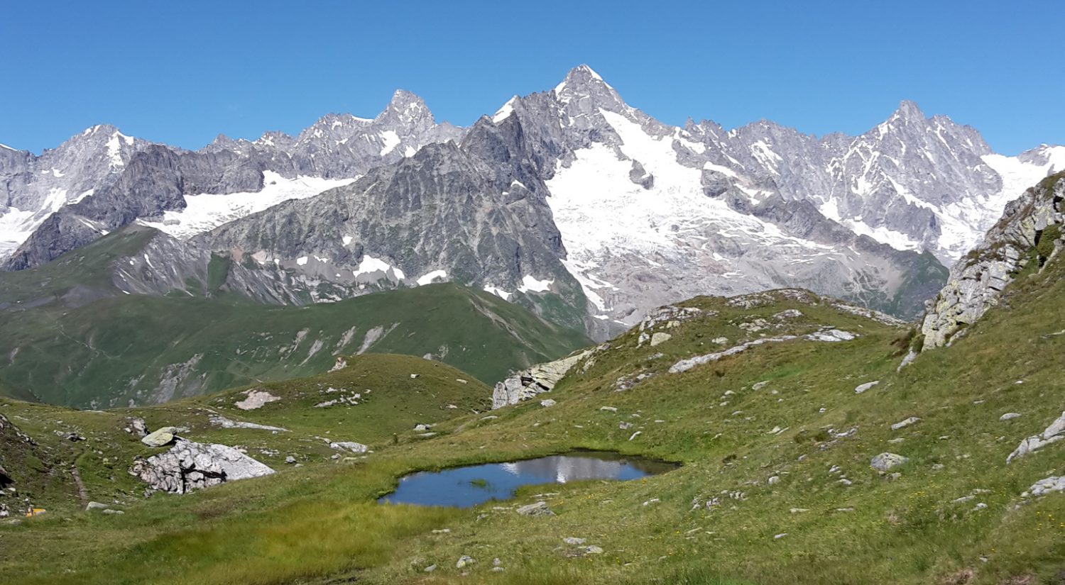
Although overcast and humid, this hike was beautiful and varied, going through the fertile valley of Sóller, climbing up 700m on the Barranc de Biniaraitx stone track to reach the Coll de l’Ofre pass with open views of the Cúber reservoir lake, the water supply for the city of Palma. The surrounding mountains were hidden in the clouds but still, we enjoyed the scenery.
We then walked along a canal that feeds into the lake and caught views of the second dam lake, Gorg Blau, before arriving at the refuge of Tossals Verds.


Bien que le temps ait été couvert et humide, ce fut une belle randonnée variée. Nous avons traversé la fertile vallée de Sóller, montant 700m sur le vieux sentier pierreux de Barranc de Biniaraitx avant d’arriver au col de l’Ofre qui nous a offert de belles vues du lac de barrage de Cúber qui fournit la ville de Palma en eau potable. Les montagnes environnantes étaient perdues dans les nuages mais le paysage était quand même beau.
Ensuite, marche le long du canal d’apport et vue sur le deuxième lac de barrage, Gorg Blau, et arrivée au refuge de Tossals Verds.

_____________________

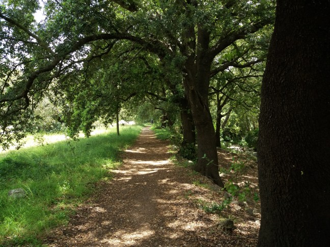
The next morning, it looked like the weather would clear but we soon found ourselves walking into fog. As the wind became stronger and moved the clouds around, we caught brief glimpses of mountain views; the temperature dropped and we had to get our jackets (and, in John’s case, gloves and hat) to keep going.
One hour before arriving at Son Amer refuge in Lluc, just as we started our descent, the sun reappeared.
Lluc is the religious centre of the island.


Le lendemain, il semblait que le temps allait s’améliorer mais nous nous sommes rapidement retrouvés dans le brouillard. Le vent s’étant renforcé et jouant avec les nuages, nous avons pu apercevoir brièvement les montagnes dds alentours. Nous avons dû porter nos vestes (et, dans le cas de John, bonnet et gants) pour continuer car il faisait froid et humide.
Une heure avant d’arriver au refuge de Son Amer à Lluc, le soleil est réapparu.
Lluc est le centre religieux de l’île.

Ruta de la Pedra en Sec

After our two+ weeks’ housesit in Geneva, we thought it was about time we started hiking again. So, we flew down to Palma de Mallorca and started hiking the GR221, aka the Dry Stone Route. We walked a couple of parts of it about 18 months ago, namely from Port d’Andratx to Sant Elm and Deia to Soller.
As this was an unplanned trip we did not have our tent and have started at stage 3; a tent is necessary for the first two stages.

We took a bus from Palma to Estellencs this morning and walked through shaded woods, along stone walls, past farm houses, with occasional views of the sea to reach the very friendly refuge of Son Trias in Esporles.


Après plus de deux semaines de housesit à Genève, il nous a semblé qu’il était temps que nous nous remettions à marcher. Nous avons donc pris un vol pour Palma de Majorque et commencé le GR221, connu ici sous le nom de Route de la Pierre Sèche. Nous avions marché quelques parties du sentier il y a 18 mois, de Port d’Andratx à Sant Elm et de Deia à Soller.
Comme ce voyage n’était pas prévu, nous n’avons pas notre tente et avons débuté à la troisième étape, une tente étant nécessaire pour les deux premières journées.

Nous avons pris un bus de Palma à Estellencs ce matin et marché sur des sentiers ombragés, le long de murs de pierres, passant des fermes avec des vues occasionnelles de la côte pour arriver au sympathique refuge de Son Trias à Esporles.


___________________________


The second day was a long hike from Esporles to Valldemosa to Deià, going up 1100+ and down pretty much the same. It would make sense to stay overnight in Valldemosa, especially if you have not visited before. We were surprised by the large number of tourists already there but, as most of them are day-trippers, the village would be quiet after 5-6pm.

Overcast until about 1pm, the weather cleared and we got plunging views of Deià and Puerto de Sóller with Puig Major, Mallorca’s highest summit at 1445m, in the background. This mountain is a military zone and not accessible to the public.


Le deuxième jour a été une longue marche d’Esporles à Valldemosa à Deià, 1100+m de montée et pareil pour la descente. Il vaudrait mieux s’arrêter une nuit à Valldemosa, particulièrement si l’on ne connaît pas encore le village. Nous avons été surpris par le grand nombre de touristes mais, comme ils ne viennent que pour la journée, le village retrouverait son calme vers 5-6 heures.

Le temps a été couvert jusque vers 13h mais, arrivés au sommet, nous avons bénéficié de vues plongeantes sur Deià et Puerto de Sóller avec le Puig Major, le sommet le plus élevé de l’île, en arrière-plan. Cette montagne est une zone militaire et donc inaccessible au public.

Entlebuch

A 5-hour long hike in the UNESCO-listed natural park of Entlebuch, passing through meadows, marsh and karst fields. Then a last push to reach the top and walk right along the ridge. Another beautiful day!


Une randonnée de 5 heures dans le parc naturel de l’Entlebuch, à travers des prés, des marais et des roches karstiques. Finalement, une dernière montée pour atteindre le sommet et marcher le long de la crête. Encore une belle journée

Pilatus

A beautiful day’s hike from the end of a valley, up 1000m to reach the top of Pilatus.
At the summit (2130m), the view is 360 degrees, and offers great plunging views of the Four Cantons Lake. The Alpine panorama is also stunning: from the Säntis in the East to the Bernese Alps and the Eiger-Mönch-Jungfrau and the Wallis 4000+m all glittering in the sun.


Une magnifique journée vers le fond d’une vallée avant de monter de 1000m pour atteindre le sommet du Pilate.
De là, à 2100m, la vue est de 360 degrés et plonge sur le lac des Quatre-Cantons. Le panorama alpin est un régal: du Säntis à l’est aux alpes bernoises. Le trio Eiger-Mönch-Jungrau et les 4000+m valaisans dominant le tout sous un soleil éclatant.