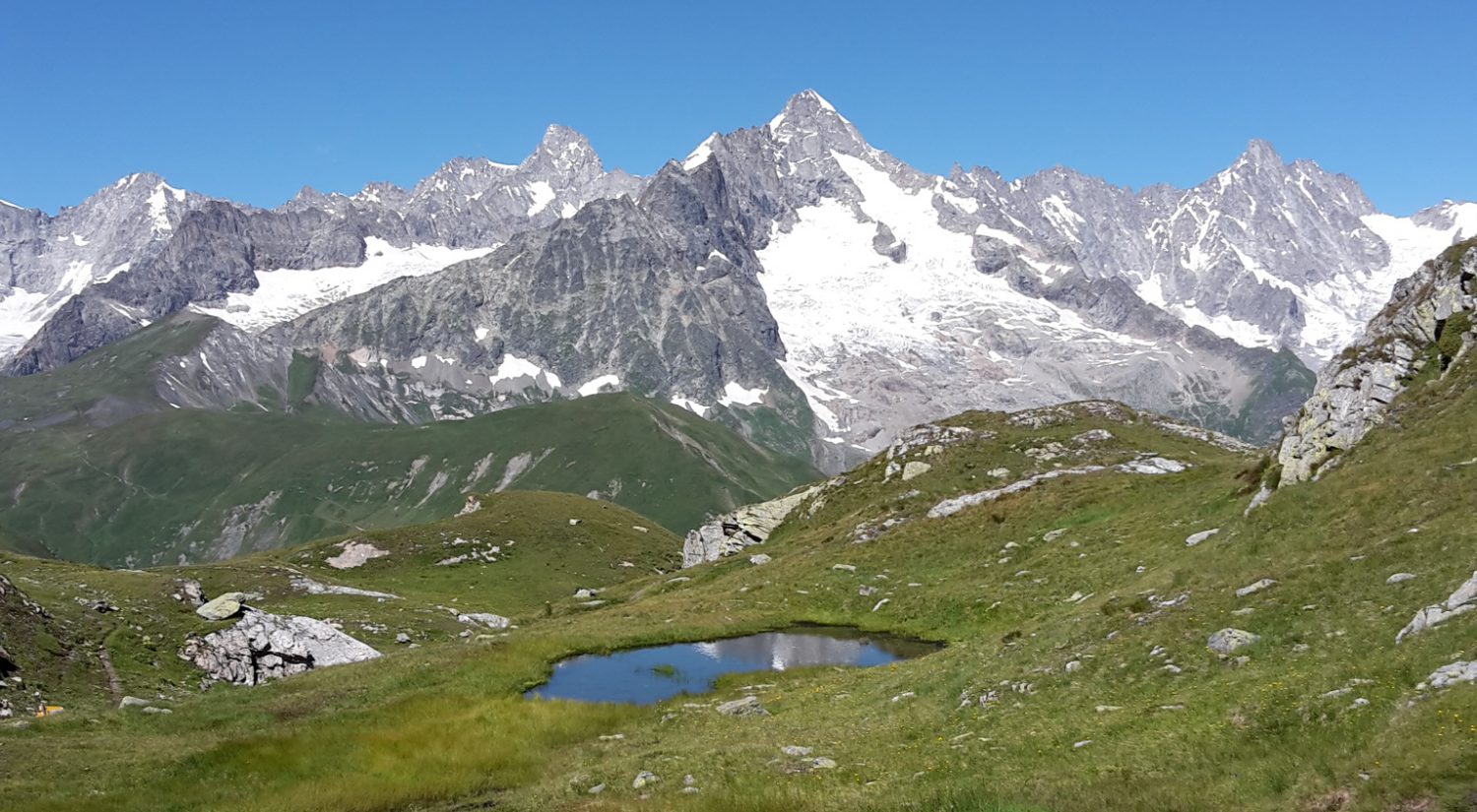
Val Blenio

Leaving the cabin, we headed due south, via waterfalls, wild rose bushes and mountain farms, where we bought delicious cheese, to reach the pretty village of Olivone, in Val Blenio. We had the menu of the day in the local osteria and met a very friendly lady. So, when finding ourselves stuck half way up the hill by chopped trees that made the path invisible, we knocked on her door and she was kind enough to host us for the night.


Quittant la cabane, nous sommes partis vers le sud, en passant des cascades, des rosiers sauvages et des fermes d’alpage où nous avons acheté du bon fromage. Le village d’Olivone, dans le Val Blenio est agréable et nous avons profité du menu du jour dans l’osteria du coin. Quand nous nous sommes retrouvés coincés, après 2h de montée et avons dû rebrousser chemin, nous avons contacté la sympathique dame rencontrée à midi, qui nous a gentiment hébergés.


Save the Greina

The Greina plain almost disappeared : in 1957, two hydro-electrical companies wanted to build an 80 m tall dam. There was public outcry against it, a foundation, “Save the Greina”, was created with strong popular support and years of battles ensued. Finally, in the mid-80s, the companies gave up on the project and the plain was saved.

It is a stunning place, a wide open plain, almost entirely surrounded by high mountains, a stream flowing through, having come out of a small canyon, and becoming a waterfall. There is a mountain hut perched on a promontory. Marmots run around, swallows fly by.
We had a picnic with a wonderful view about half way down into the plain. The cabin da Terri is visible on the photo.
We then moved on to our next hut.


La plaine de la Greina a failli disparaître. En 1957, deux compagnies hydro-électriques ont voulu construire un barrage haut de 80m. La population a réagi négativement, une fondation “Sauver la Greina” fut créée et des années de lutte furent nécessaires avant que les compagnies renoncent à leur projet au milieu des années 80. La Greina était sauvée.

C’est un endroit magnifique, une grande, large plaine entourée de hautes montagnes, traversée par un ruisseau, sorti d’un petit canyon et finissant en chute d’eau. Il y a une cabane perchée sur un promontoire. Les marmottes courent à travers la plaine et les hirondelles y volent. Nous avons pique-niqué à mi-chemin avec une vue superbe. La cabine du Terri est visible sur la photo. Puis nous avons continué jusqu’à notre prochaine cabane.

Arriving in Ticino

Choosing the ibex, the symbol of the canton, for the first photo seems appropriate on the day we leave Graubünden to enter Ticino, the Italian part of Switzerland.
After a climb of 1,000 m up the mountain, we reached our first pass of the day and discovered the plain of the Greina, a beautiful place (worthy of a separate post, to follow).
The second pass led us down, sliding on snow, to Capanna Scaletta (2205 m), our first mountain hut, after 3 nights in our tent. The delicious smell of the stew simmering away confirmed we had arrived in Ticino.
We rewarded ourselves with a beer on the terrace, overlooking the valley, the next day’s destination.


Le choix du bouquetin, symbole des Grisons, comme première photo semble approprié le jour où nous quittons le canton pour entrer au Tessin, en Suisse italienne.
Après une montée de 1000 m pour atteindre notre premier col du jour, nous avons atteint la plaine de la Greina, magnifique et spectaculaire (qui mérite un autre poste, à suivre).
Le deuxième col nous a amenés, après une glissade sur la neige, à la Capanna Scaletta (2205 m), notre première cabane après 3 nuits sous tente. Le fumet du plat qui mijotait nous a confirmé que nous étions bien arrivés au Tessin.
Nous nous sommes installés en terrasse pour prendre une bière bien méritée tout en admirant la vallée en contrebas, destination du lendemain

Val Lumnezia

Bun di !
Shortly after leaving Coire, we entered one of the romansh-speaking areas of the canton. It is a Latin-based language, close to Italian and French and Ladin, one of the dialects of Northern Italy. It is Switzerland’s fourth national language.
Val Lumnezia is an agricultural valley. Typical Romansh villages (although architecturally different from the Engadine) and tiny huts are scattered on the high plateaux.

Bun di !
Peu après avoir quitté Coire, nous sommes entrés dans l’une des régions romanches du canton. C’est une langue latine, proche de l’italien, du français et du Ladino, dialecte du nord de l’Italie. C’est la quatrième langue de Suisse.
Le Val Lumnezia est une vallée d’agriculture de montagne. Des villages typiquement romanches (bien que l’architecture y soit différente de l’Engadine) et de petits mazots sont éparpillés sur les hauts plateaux.

Along the Rhine

Leaving Coire/Chur ( the cheapest spot on Swiss monopoly) mid-afternoon, we walked along or above the Upper Rhine valley. The Rhine is then still an impetuous mountain river, narrow in its gorges and very wide but shallow near Ilanz. We ended the day beautifully, invited by a welcoming family from Olten to share their very impressive barbecue meal.


Le long du Rhin

Nous avons quitté Coire dans l’après-midi et remonté la vallée du Rhin antérieur. Le fleuve est alors une impétueuse rivière alpine, à l’étroit dans ses gorges et très large mais peu profonde près d’Ilanz. La journée s’est terminée agréablement, invités par une chaleureuse famille d’Olten à partager leur repas, un très impressionnant barbecue.